Romlor one needs a new route

Hello,
This is a slightly different request to my others. Romlor two exists which is a workable route so we do have a route for Romlor that is functional.
Please would anyone like to take a look at Romlor one and see if a better version of it could be suggested? At the moment Romlor one doesn't work and needs to be removed. There are clear reviews of the issue around access and a suggestion to possibly incorporate The Test Way.
Best wishes,
Cristie
-

I'm happy to have a look at this one Cristie.
0 -
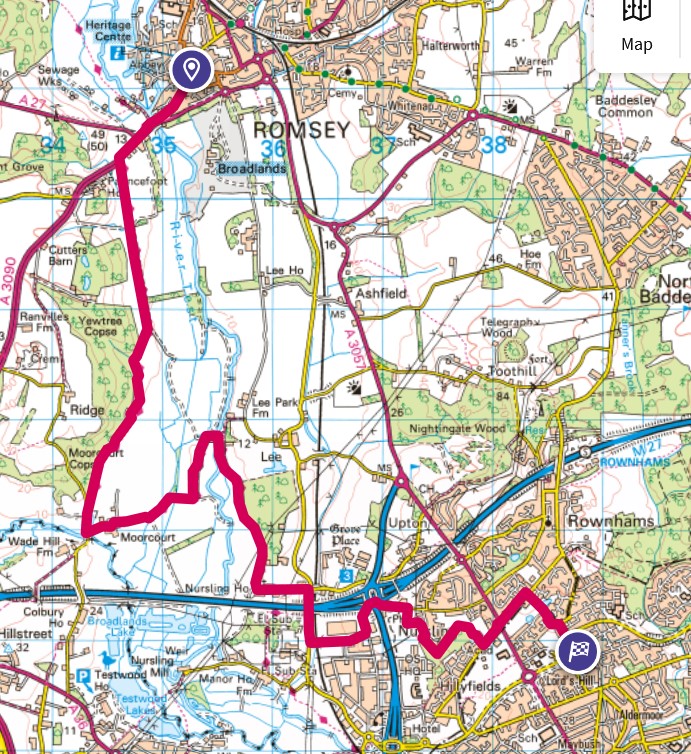
First look, taking it via the Test Way adds another 3km, but on first glance makes it a viable route all the way. Will proof and study on street view later.
0 -

Not my area but an interesting case so I had to do some digging. But I'll leave it to others to explore.
-
The Broadlands track is shown on Find my Street which shows in map form the National Street Gazetteer (NSG). It does say that the route is not maintainable at public expense but that's another issue that does not affect any public rights along it. (A private street is land not maintainable at public expense irrespective of any access rights to the public. Kent CC)
-
The Ramblers as part of the 'Don't Lose Your Way' project have identified the route as a potential claim but now that the 2026 deadline for claims has been removed it may be many years before the status of the track is confirmed.
-
Looking for a less contentious route the Test Way as suggested appears promising but at the south end the roads are narrow. I looked at the tracks through Nightingale Wood and found that Test Valley Borough Council published a report in 2011 about access here. So this suggests while no improvements are evident there could be access. But I can't determine an entry exit point on the east side into Upper Toothill Road.
0 -
-
Thank you Andrew for taking it on and Ken for doing some more digging. An interesting route. Will keep my fingers crossed.
Best wishes,
Cristie0 -
I have made an alternative using Test Way, as without additional on the ground knowledge, the Eastern route options seemed limited.
Only bits - small section of verge/ behind the armco walking at Station Rd (here).
Possible footpath diversion/ closure (here) at Redbridge Ln near Cedars School. Looks open but plenty of development off that route which might mess with the footpaths. Hopefully not with the OS so near! Alternative is going via the footpath past the OS that leads to the SW on the same road. Needs on the ground testing.
Hopefully a good alternative to test. Tried to find a solution to the east but no luck. 12.8km so an increase of 3km on the original, but now at least walkable *I hope*! Will upload tomorrow, the OS website isn't letting me download a gpx on Firefox or Edge tonight...
 0
0 -
Thanks ever so much Andrew. I'll take Romlor one from the network.
Best wishes,
Cristie0 -
No worries Cristie. It's live now here but the website has tagged it Romlor 4. Not sure if it's worth reassigning.
0 -
Thanks Andrew. Romlor four is great. I don't have a way to make it another number so it can be it's own self.
0
Please sign in to leave a comment.
Comments
8 comments