Network review - We'd love your comments

- Your general opinion on any/all of the changes
- Any errors that you might spot from the changes we've made (e.g. we've added a new place and not all of its associated new Slow Ways)
- Any essential changes to the network that you think are required that we may have missed. Please keep in mind that we have plans to create that denser layer of routes in the future. We do know there are lots of places that deserve nodes!
- There were some suggested Slow Way places and routes which we felt would be part of another (or denser) layer and so aren't for just now.
- There are other changes that we're looking at such as increasing the number of nodes of Scotland's islands. These need more work and so will be left for the next review, or for the denser layer.
- March 21st - Deadline for any comments
- March 23rd - Final map/list of changes will be created
- March 24th-26th - Route creation sprint: a sprint to draft pioneer routes for all new Slow Ways
- March 27th - Urban Good will add the routes to the new printed map
-

Hi Cristie,
Just some quick feedback about the changes nearest to me:
The inclusion of Aust in the proposed denser network seems appropriate.
The proposed Meeting Point looks good too: by the Evangelical Church, NCN route signposts and the Boar's Head pub.
Three of the four existing SW / Routes will naturally pass by or very close to the MP.
Kind regards,
Phil
0 -
Hi Phil,
Thanks for taking a look. It's much appreciated. Would you be interested in helping with some route creation if Aust is added?
Best wishes,
Cristie0 -

This is great Cristie.
Stapleford Tawney will be no more! I'll take a look at the others near SE London soon. Definitely up for some route creation near there too.
Are they all movements? I was looking for a deletion somewhere in SW Wales but can't see a likely candidate. A single line was redundant because it crosses a deep estuary i.e. goes all the way round it, no bridge. And there is another waterfront settlement/resting place just at the head of the estuary. The crossing line goes through there and so it is functionally equivalent to a pair of those lines. Maybe it was around Carmarthen?
And something similar, but much more complex is happening near Pembroke and Pembroke Dock even further west. Sinuous waterways and crossings limited to bridge (or bridges?), so links between four or five settlements were all woven together, crossing over, intersecting and diverging. It is essentially impossible to see which route is which from the Slow Ways website and decide which to select. Testing would have involved lots of covering almost the same ground over and over. I'm sure there is a way to rationalise it but I lost patience with the detangling process.
But I can't see anything in South West Wales :-/
Cheers
Daisy0 -
Hi Cristie,
Yes, of course, I'd be happy to help with some route creation related to the inclusion of Aust.
Kind regards,
Phil
0 -

It's good that Shetland has gotten an extra node, but the distances are IMO still too long to go and check! I would also very much like to see a Kilburn to Euston Station route.
cheers,
Derick0 -

Stapleford Tawney correction seems very logical. Found the original comments on the settlement in the Buzzards settlements excel sheet "tiny hamlet on back lane with no facilities. Churchyard entrance".
It was also not even on the less populated places list on the original Google Maps TIN , so I think it must have been added to fill a 'cross-roads' and in hindsight there's obviously a better option.
Very happy to be part of any sprint (brings back good memories of 20/21!) Will have a look at the other suggestions over the weekend. If we need links to any of the original maps or excel files of settlements I have them all bookmarked!
0 -

My local change is the addition of the NEC as a node. It seems slightly strange that somewhere that people stay rather than live is a choice of node, especially as there are still no nodes in the east of Birmingham (I take it from the precis that there might be some added as part of a next phase, but I'm finding it hard to get people interested in Slow Ways because of the distances of the routes from the City Centre). I welcome the addition of the new node, as it looks like it would enable a more direct inter city route between Birmingham and Coventry. On first look I'd probably plot the same route from Birmingham along the Grand Union Canal as far as Olton and then try and figure it out from there. So yes, thumbs up to the addition of the NEC. I'd definitely be interested in reviewing if not plotting it too. On a further local theme, Stoke City Centre (Hanley) still needs a node.
0 -

Most of the changes look sensible to me, and I welcome the additional routes at Hayfield and Edale that resolve the quadrilaterals into triangles, I'd be happy to help with plotting those, and with any others for which nobody has good local knowledge.
0 -

This map really needs a node at Grateley in Hampshire. It really doesn't need one at Bulford Camp.
I realise Grately isn't a big place and could appear on a denser map, but the reality on the ground is that the MOD and Porton Down dictate where people can actually walk starting from Amesbury. Appreciate these aren't huge distances, but
- AMEKIN is 20 miles long.
- AMEAND is 17 miles.
the first two miles out of Amesbury are the same for each route, and then they take slightly different paths before both go right past Grateley Station anyway.
In two years nobody has rated either route and unless someone comes up with a special event, I can't see either ever being widely used.
Bulford Camp meanwhile has 4 routes. Two are very short and UPABUL is practically a duplicate of UPAAME. Importantly, the 4th crosses the A303 (the busiest dual carriageway in the area) at a point where there are no facilities to aid pedestrians. The local parish councils don't highlight the path and it requires pedestrians to look far a gap in two lanes of traffic, scramble between the road barriers and then look for a gap in the traffic on the other carriageway. This was fine in lockdown and light traffic and I've nothing against individuals making a personal choice to use it, but encouraging people to take this route is irresponsible and risks causing problems for slowways.
In 2 years, nobody has rated any of these 4 routes either, so removing Bulford won't actually lose any reviews either.
0 -
I have reservations about adding Troed-y-rhiw in the Welsh Valleys. I think reorientating the triangle to join Merthyr and Treharris instead of Mountain Ash and Rhymney is a better simpler solution for now.
If I remember correctly you can't *legally* go over Cefn Merthyr except right next to Merthyr or Treharris so it'd just add duplication. There's a similar but less extreme problem between Mountain Ash and Troed-y-rhiw. It would be good to have the Taff Valley in the network though, it is an obvious gap in the Routes around here. The new diagonal would use it, and the Taff Trail and the Trevithick Trail would make it straightforward to plot.
The direct way from Mountain Ash to Troed-y-rhiw might be do-able because there's a lot of access land, but I think it'd be pretty off-grid, orienteering skills required. An easier to navigate route from maps would go further north, but it would probably overlap with MerMou 1, which has 3 x 2 star reviews.
I must have plotted some routes near here as I have memories of the research, but if someone else knows of a good path that I didn't find this isn't a hill I'm willing to die on, as it were.
ETA there was (is?) a system of Welsh landowners making permissive routes in exchange for the Welsh equivalent of countryside stewardship subsidies. That might help here. But IIRC the system was in the middle of an overhaul, details of the new one weren't available, neither was a comprehensive Wales-wide map.
0 -
Thank you so much for all your suggestions and contributions. I'm working my way through them now, so may ask questions as I go.
Best wishes,
Cristie0 -
Thanks again everyone for your suggestions and help. I've now sent an email with instructions and links for all those who offered to help with the sprint.
If you've not received an email and you offered please know that it's my human error. Please ping me an email at hello@slowways.org and I can get you started.
Best wishes,
Cristie
0 -
Hi Cristie. Some of the changes that will happen might affect route reviews I've already written. I.e. near Swanscombe,Kent and Beckenham, London. If they are going to disappear 'd like to save a copy first, maybe the photos too. That'd save me time when posing reviews of replacements as they will probably overlap at least a little.
Other people have reviewed some of them too but my not have heard about the Network Review. Perhaps they'd like a notification so they have a chance to do the same?
0 -
Hi Daisy,
That's a good idea and we're thinking similarly.
I have a list of people to contact as we get closer to the change happening. There's also this story which I'll pop here in case you haven't seen it. It's also going in a newsletter soon.
If people do lose access to their review then fear not as we can also get to the data behind the scenes.
Best wishes,
Cristie0 -
Hi Cristie,
Any news on the implementation of the network changes detailed in the Sprint?
Particularly, when might we see Aust and its connected Slow Ways / Routes appear?
Kind regards,
Phil
0 -
Hi Phil,
Sorry, it's taken ages. Yes, I have some good news and hopefully the changes will be made in the next few weeks. When they're up I'll pop a note on here and also email everyone who created a new route so they have the option to upload their creation.
Best wishes,
Cristie0 -
That is good news! Does “the option to upload their creation” mean our new routes won't be uploaded automatically? I think I still have the ones I submitted, and I guess resubmitting them ourselves will mean that we get notified of any reviews.
0 -
Yes, I thought you might like first chance to upload the route you created and have your name by it. I have all the files if anyone needs a copy of theirs. I'll also set a date (probably a week or two) after which I can upload any of the remaining ones :).
Best wishes,
Cristie0 -
Hi Everyone,
This is a wee update to say that some of the network edits are now available.
If you helped in route creation and your routes now exist then I've sent you an email.
If yours are still to come (this week hopefully) then I'll email you when they're ready.
You'll have the option to ask me to upload them if you'd rather and if you need gpx file copies then I can find them for your too. That will all be in the email.
Very exciting to have them nearly there.
Best wishes,
Cristie0 -
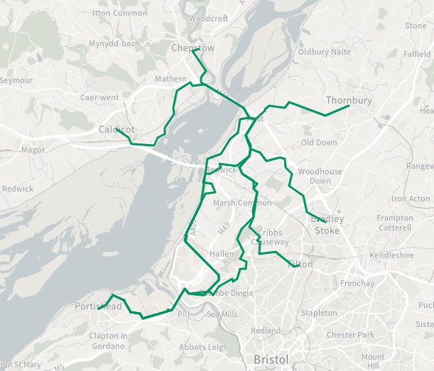
I'm pleased to report that I have uploaded the following new routes to/from the new settlement node Aust (Gloucestershire), created during the March 2023 Sprint:
Ausbra one (Aust-Bradley Stoke), Ausfil one (Aust-Filton), Austho one (Aust-Thornbury), Calaus one (Caldicot (Cil-y-coed)-Aust), Cheaus one (Chepstow-Aust), and Poraus one / two / three (Portishead-Aust).
They are based on the most popular of the previous longer routes that existed before Aust was added to the network, and all have been fully plotted from scratch fully to improve fidelity.
Two additional routes are provided for Poraus (Portishead-Aust):
Poraus two - to cater for the ongoing sea defence works (until 2026-27); and
Poraus three - to provide a permanent inland alternative route using sections of the Forest Community Path.Note: to find Aust from ‘the snail’, you currently need to type “Aust (gl” (or as much as “Aust (gloucestershire)” as you like).
Best wishes,
Phil
 0
0
Please sign in to leave a comment.
Comments
20 comments